Gudbrandsdalen
Valley of Gudbrandsdalen, Norway
The Gudbrandsdalen is one of the most populated valleys in Norway, extending for distance of roughly 140 km from the town of Lillehammer in the south to the village of Dombås in the north,. The area is rich with flood plains along the river that are extensively used as farmland. Furthermore, due to lack of other available land, many settlements are located along the river.
The valley and side valleys are exposed to a range of hydro-meteorological hazards, flooding in the main river and tributary rivers, debris flows and debris slides, rock fall and snow avalanches. Two NBS interventions have so far been proposed for the Gudbrandsdalen case site, one of which later has been cancelled. The other, a Living Lab stakeholder process has recently been approved, whereas there are two other proposals soon to be submitted to PHUSICOS.
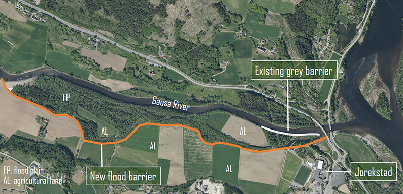
Jorekstad receded flood barrier
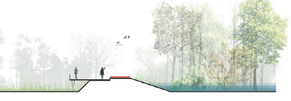
The river Gausa, a tributary river to Gudbrandsdalslågen, experiences regular flooding, with occasional extreme events, such as 1995, 2011 and 2013. The frequency and severity of extreme events is expected to increase over the coming decades. The lower parts of Gausa at Jorekstad, where the river meets Gudbrandsdalslågen, is particularly vulnerable, with agricultural land, housing and infrastructure such as football stadium.
A receded flood barrier, which allows the river to flood the floodplain riparian forest and the nearest farmland during extreme events, will significantly reduce the risk for areas outside of the barrier, and reduce erosion and sediment deposition in the confluence zone with the main river, where this changes the river bottom and leads to increased flood problems.
Co-benefits
In addition to reducing the flood risk of the area, the measure will:
- Preserve the riparian vegetation on the floodplain and enhance biodiversity of this important area
- Carbon storage in the preserved vegetation.
- Reduce runoff of soil, seeds and nutrients, as well as pesticides from flooded farmland and possibly microplastics from nearby football fields with artificial grass
- As it will appear green and nice, it will increase the population’s well-being, support multiple activities such as a fishing platforms, picnic area, and panoramic views, and provide opportunities for hiking, running, etc.
- The building and maintenance of the measure will serve to prove that there are local jobs related to the green shift, and may thus boost the local economy.
Cancelled due to cost overrun
Unfortunately, the detailed design of the barrier revealed that the cost estimate had been far too low, and that the real cost of implementing the measure would be around 100% higher. Great efforts have been undertaken to find a solution to this, including assessing additional funding possibilities, as well as reduced ambitions for the barrier. However, a reduced barrier would not serve the PHUSICOS objectives, and additional funding possibilities have proved far too small.
The consequence is therefore that the receded flood barrier has been cancelled as a PHUSICOS implementation project. However, the Jorekstad project has provided other results in form of experience with governance issues, the WP4 baseline assessment has been done, and the case is still being used as a case for WP6 in their development of VR learning tools for NBS.
Skjåk Living Lab process
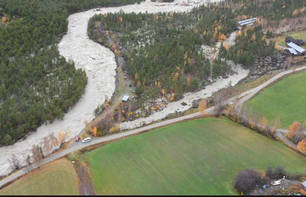
The municipality of Skjåk in a side valley in the norther part of the Gudbrandsdalen, is one of the driest areas in Norway, with a mean annual precipitation of only 300 mm. The area experiences severe flooding problems, and particularly as late as in October 2018, a a very early heavy snowfall followed by unusually warm weather resulted in a severe flood.
This is the background for the Innlandet County Administration’s (ICA) proposal to run a full Living Lab stakeholder process in the municipality. An initial open meeting has been held, but the process was halted due to Covid-19 restrictions. The plan is to run the process from scratch and discuss various solutions, also including grey and hybrid solutions to the problems, in addition to NBS, with the aim of concluding on a sustainable NBS intervention as the most viable mitigation strategy.
ICA plan to hire a professional facilitator for the process, as they will not be an independent part in the process, being also the regulatory authority in this area. The LL process is planned to start as soon as a facilitator is in place, probably during the spring of 2021, and will then run through 2022 in a form which largely depends on the Covid-19 restrictions. The goal, however, is that most of this process will be done through physical meetings.
New proposals
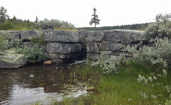
Skurdalsåa flood retention in Sør-Fron municipality
It will consist of utilization of an old (ca. 1870) dam made by local stones, originally built for household water and irrigation purposes, to retain flooding in Skurdalsåa, another tributary river to the main river Gudbrandsdalslågen. Skurdalsåa responds rapidly to precipitation and snow melt, and flooding has repeatedly caused damage along the river. By lowering the gate threshold and increasing the height of the old dam of roughly 0,5 m, flooding can be delayed by 2 days, giving ample time to take measures along the river as well as ability to let water out in a more controlled way. There are hundreds of similar old dams in Norway, and the upscaling potential of this relatively simple measure is therefore huge.
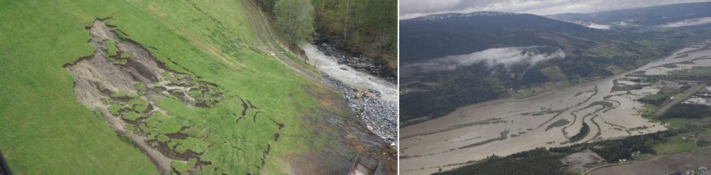
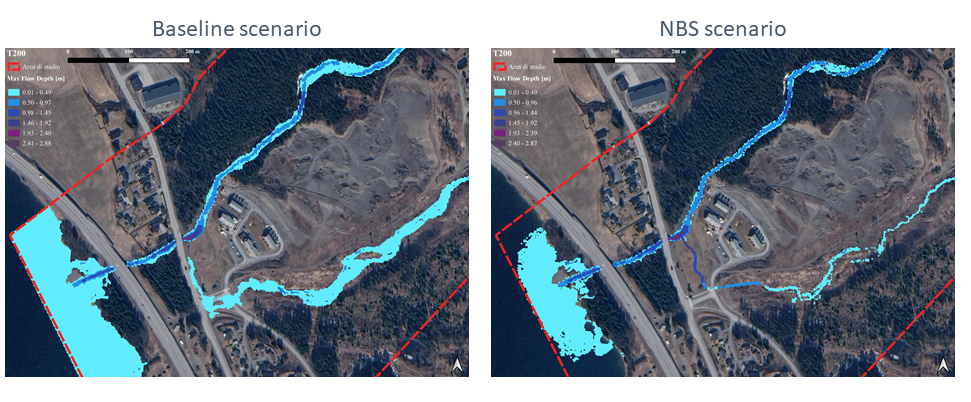
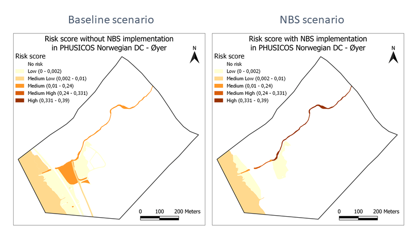
Trodalen housing development, Øyer municipality
was stopped by the national authosrities due to potential flood hazard, which has to be mitigated. A proposal to PHUSICOS is under evaluation, which includes the use of experimental vegetation along one of two streams in the area to reduce energy and erosion potential during floods. This will be combined with a sedimentation dam (check dam) and establishing a blue-green park area downslope of the family houses. This will serve as a playground and leisure area most of the time, but as a retention basin during floods.
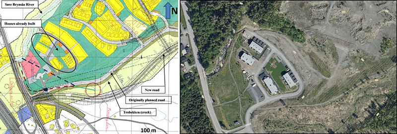
Right: Aerial photo of the area, as it is today.
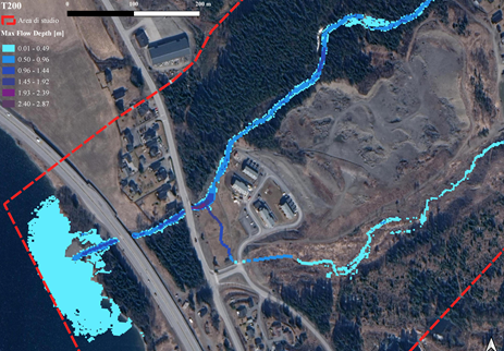
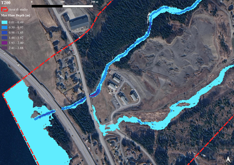
Results for the øyer site:
Max flow depth for a flooding event having a return period of T=200 years
Mohammad Aminur Rahman Shah, Jiren Xu, Francesca Carisi, Francesco De Paola, Silvana Di Sabatino, Alessio Domeneghetti, Carlo Gerundo, Alejandro Gonzalez-Ollauri, Farrokh Nadim, Natasha Petruccelli, Annemarie Polderman, Francesco Pugliese, Beatrice Pulvirenti, Paolo Ruggieri, Giuseppe Speranza, Elena Toth, Thomas Zieher, Fabrice Renaud (2023). Quantifying the effects of Nature-based Solutions in reducing risks from hydrometeorological hazards: examples from Europe. International Journal of Disaster Risk Reduction (under review)
======================================================
Contact person: Turid Wulff Knutsen, Turid.Wulff.Knutsen@innlandetfylke.no