Informations
Solution ID
Description of solution
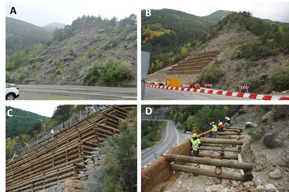
At this site, landslides and rockfall from a steep, ca. 35 m high slope consisting of loose glacial till, threaten an important road between France and Spain, the A-136 (RD-934 in Freance). With low road visibility and high traffic speed at the site, risk is mainly connected to rocks lying in the road. Mitigation with rockfall nets has proved insufficient and release of boulders and smaller rocks due to erosion has persisted.
Through the H2020 project PHUSICOS the slope has been reshaped through terracing techniques, with the establishment of vegetation to stabilize the sediments.
The measures implemented at St. Elena consist of terraces formed by a 5 m high dry masonry wall at the base followed by 10 terraces constructed using wooden logs. The log constructions are in the form of timber gabions, and these are filled with local sediment and a 10 cm layer of organic soil on top for planting of bush vegetation on the terraces. In addition, ca. 1 m deep holes are filled with organic soil at 3 m intervals along the terraces for the planting of larger trees. Each log terrace step is roughly 2 m high. The width of the construction is 32 m at the base and narrows off to ca. 20 m at the upper, 10th terrace.
All dug-out material is used in the construction, mainly for fill of the gabions. Additional sediments and organic soil had to be brought in to enhance the revegetation process. All plants used are local and adapted to the climate, altitude, and the local geology (glacial till) (Pinus sylvestris, Betula pendula, Sorbus aria, Populus nigra, Salix capraea, Hippophae ramnoides and Salix eleagnos).
Eventually, after ca. 20-30 years, the wooden gabions will no longer be the main protective agent, and the vegetation itself is expected to maintain stability of the slope.
Co/benefits:
- less frequent need for maintenance and repair, probably leading to reduced costs over time
- increased sense of safety for users of the road, particularly regarding transport of goods between the two countries
- aesthetic benefits, and combining the measure with the system of foot-paths in the area
- Challenges for the implementations encountered in the Pyrenees are mainly bureaucratic and related to the procurement process as well as to obtain necessary permissions to do the work.
Keywords
Exposition
Actors
- Reshaping the slope through terracing techniques have been implemented through the H2020 project PHUSICOS.
- The activities are coordinated by CTP (e Consorcio de la Comunidad de Trabajo de los Pirineos), but the proponents and 'owners' of the implemented measures are the regional organizations ONF-RTM EGTC Pirineos - Pyrénées (Santa Elena)
Temporal aspects
Others
https://phusicos.eu/case_study/the-pyrenees-spain-france-andorra/
The position of the implemented measure is not exact